The City of Saint John was Not Meant to be Shared. Are We Sharing Now?

A few weeks ago, I spoke with Julia Wright on CBC’s Information Morning about how the city of Saint John was not meant to be shared. I explained that the 1785 city charter was designed, at least in part, to cut Wabanaki people off from the harbour (in violation of Treaty) and to restrict all the “liberties and privileges of freemen” to “the American and European white inhabitants” of the city.1

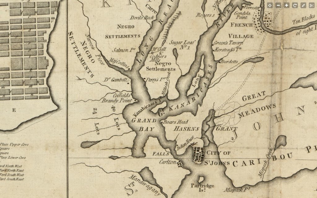
On Twitter, my friend Daniel Samson, an historian at Brock, shared this 1797 map of the area that very clearly highlights authorized Black settlement spaces well outside of the city limits. Daniel discusses these exclusions as part of a much larger heritage of systemic racism in the Maritime Provinces, powerfully concluding that “our communities are material legacies of 18th-century strategies of inclusion, denial, and removal.”

You can listen to my discussion with Julia, which engages some of my current research about Saint John, here on the CBC website. In addition to the city charter, I spoke about the Bentley Street portage route and the former Wolastoqey village that is now a fenced-off part of the city Port and a footing for the Harbour Bridge. Before the bridge was constructed in 1968, a ferry bearing the name of the Wolastoqey village — Ouangondy — connected west Saint John with the city’s uptown.

Source: New Brunswick Museum, The Ouangondy, Saint John Harbour Ferry Boat, docking at the Rodney Wharf, West Saint John, New Brunswick, c.1910. 

One thing that I didn’t have time to talk about in the radio piece was Fort Frederick. Near the Wolastoqey village site, in front of what is now the Carleton Community Centre, there is a marker for Fort Frederick, a site with its own fraught and complex colonial history. But something that is forgotten in the current commemoration material around that site is that there was a truck house at this location prior to the arrival of the Loyalists.

I like to remember the truck house because it helps me reflect on those agreements that my ancestors made to live in this territory alongside their Wabanaki partners in Treaty. In the Peace and Friendship Treaties, the British promised to establish truck houses in and amongst their settlements where Wabanaki people could freely and easily sell and trade their goods. Continuously facilitating Wabanaki access and economic participation in this way was just one specific condition that the British agreed to – in exchange for the amazing right to live here in this beautiful place at all.

And so a truck house master named John Green was stationed at Fort Frederick to ensure this access and to tend to this one aspect of the Treaty relationship. Tending to this relationship is something that my ancestors decided we didn’t have to do anymore once the Loyalists arrived and gave us a majority status in the region. When I remember that there was a truck house in this location, it helps me assess whether we are, as a city, continuing to operate in violation of those historic agreements — continuing to consolidate ourselves against a space that we are still not willing to share.

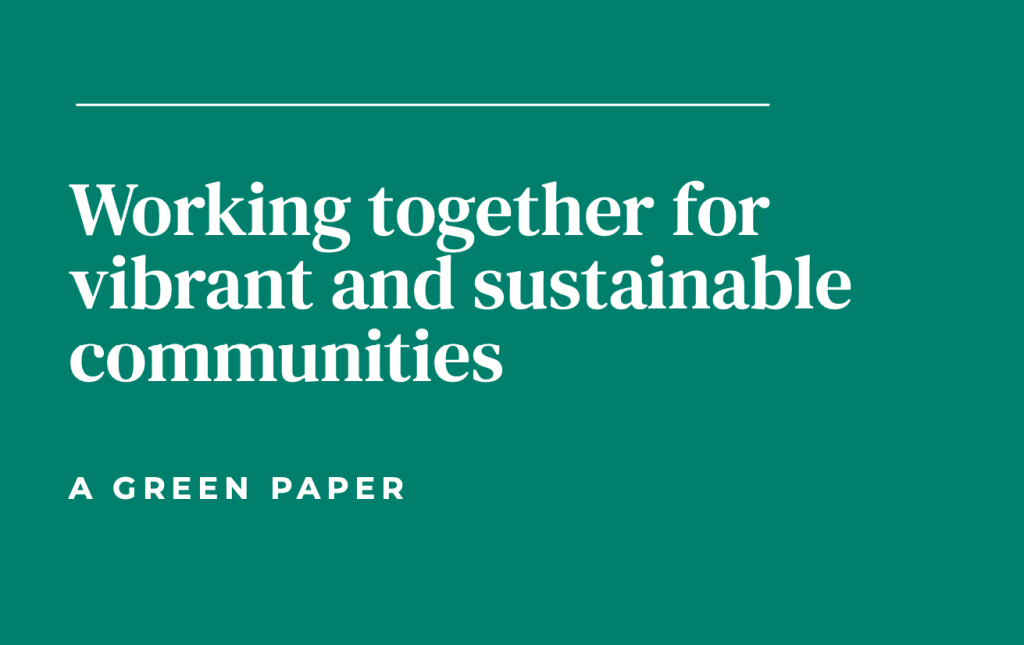
Yesterday, the Green Paper on Local Governance Reform was released by the Province of New Brunswick to great interest and fanfare. The document contains one instance of the word “Indigenous” (in a demographics chart) and one instance of the word “treaty” (in a reference to western Canada). And so are we acting as partners or as rulers? Are we ensuring Wabanaki access or economic activity and participation in a manner that is consistent with agreements that were made on our behalf many years before spaces like Saint John were chartered — or are we continuing to ignore our responsibilities under Treaty and to represent the structures of our cities and municipalities, the “material legacies of 18th-century strategies of inclusion, denial, and removal,” as the primary conditions of belonging and participation in this territory?

_______

Notes:

1 The argument that the city charter cut off Wolastoqiyik access to the harbour salmon fishery comes to me, as noted in the radio interview, from Jason Hall, Ethnohistorian for WNNB.

Research Notes: New Brunswick correspondence on birch bark (early 20th century)

Back in early June, I published a research note on a poem written on birch bark. In an update to that note, I indicated that Peter Larocque at the New Brunswick Museum had e-mailed to suggest that the poem’s author, “Argole,” was probably Arthur Gordon Leavitt, one of the founders of Camp Nature in Nerepis — “ARGOLE is most likely an acronym using the first two letters of each of his names.” I agree that this seems likely, and I was very grateful to receive Peter’s message. I sincerely appreciated all of the information that was sent to me after that note was published.

Because I am currently interested in any and all regional writings on birch bark, I returned yesterday to Loyalist City Coin and asked Donnie, Ross, and Doreen at the counter if they were aware of any other such writings in the store. A binder of novelty postcards contained the following items:

Document 1 (3 images)

Three pages of bark are bound with two pieces of string. “Canada Post Card” is written at the top of the first page in pencil beside a sketched postage stamp. The document is addressed to “Miss M. Lizzie Muir, Hatfield’s Point, Kings Co., N.B.” The second page includes sketched flowers, a bird carrying a note, and the words “A Message With best Wishes for Many Happy Birthdays” written inside overlapping hearts. The final page is dated “Feb. 15th 1907.” A poem reads:

Dear Lizzie,

May you be happy,

Of sin be afraid,

But for “gracious sake” Lizzie,

Don’t be an “old maid.”

Mrs. M.P. Ogilvie


Document 2 (2 images)

One sheet of bark; on the front, “Canadian Post Card” is written in blue ink beside a 1 cent postage stamp. The bark has been damaged, so the addressee is unclear, but quite possibly it is the same as above, since “Hatfield’s Point, Kings Co., N.B.” is legible. A postmark appears to date this document March 23, 07 and shows the word “Ogilvie,” which matches the surname of the author from Document 1. The back of the postcard features a sketched flower and text that, save a few scattered words, is very difficult to read. The black ink text includes the words “you send me a mag-nifying glass in the mail.” In blue ink, the words at the very bottom of the page read, “Later accounts. Please send a Hindoo Interpreter.”


Document 3 (2 images)

A poem addressed to “Miss Bertie J. Darrah” of “Chipman, Queen’s Co. N.B.”:

“Well is the man who has old clothes

And has a wife to mend them

But better still he has old “doughs”

And has a heart to spend them.”


Document 4 (2 images)

Numerous thin sheets of bark are adhered together. One side reads, “Souvenir of Rattlesnake Lake Winnipesaukee New Hampshire;” the other begins,

August 20th 1913

90 Sheridan St

Lakeport NH

Dear Lizzie,

I am sending you a souvenir, taken from Rattel Snake Island on the wonderfull Lake Winnipesaukee that which has as many islands as their are days in the year & this one is uninhabited [?] of the Rattle Snaks so I [?] curious to go on it & Brother took us to see it, he also took us to see the great wreck on the shore of the Lake & I walked through 2 of the cars and sat down on the 2nd one so got a piece of the splintered car for [?] . . .


I found record of a Mary Elizabeth Muir, born in 1894, in the Provincial Archives’ Vital Statistics database, and I believe this is likely the “Lizzie” addressed in these notes. My best guess is that the author, “Mrs. M.P. Ogilvie,” is Lucy Anne King, who married Malcolm Peter Ogilvie in Kings County in 1901. Malcolm died of “Consumption” in 1908 at the age of 32 — after Documents 1 & 2 but before Document 4. They had four children.

Another postcard that I came across, featuring imagery from the 1904 “Champlain Celebration” in Saint John, might suggest that dropping pieces of birch bark into the mail was more commonplace than we remember.

Teaching Mihku Paul’s “The Water Road”

Mihku Paul gave me this beautiful copy of her poem “The Water Road” after I organized a reading for her at the Saint John Free Public Library several summers ago. This now hangs in my kitchen and I look at it when heating bottles of milk for my babies. It’s one of my favourites of hers, but also, more generally, one of my favourite things ever written about the Wolastoqiyik homelands.

IMG_5204

And because it’s featured in the wonderful Dawnland Voices: An Anthology of Indigenous Writing from New England (ed. Siobhan Senier), I have the privilege of discussing it with students this week in a third-year Indigenous Literatures course at the University of New Brunswick in Saint John. To some degree, the poem is a response to The Old Meductic Fort and the Indian Chapel of Saint Jean Baptistea paper that was read before the New Brunswick Historical Society by Rev. W.O. Raymond in 1897. Raymond refers to a tributary of the Wolastoq River that the Maliseets call “Madawamkeetook, signifying ‘rocky at its mouth,'” and also to a report penned by Abraham Gesner — the Settler geologist who invented kerosene — who noted, in his survey of Wolastoqiyik portage paths, that the “‘solid rocks'” between Meductic and Tobique had been so well travelled that they were “‘furrowed by the moccasins of the native tribes.'” Gesner’s writings on these trails are themselves fascinating, filled with detailed references to awikhiganak, the images inscribed into tree bark that helped Wabanaki peoples navigate dense forests.

Against this incredible image of people traveling, for centuries, down worn and familiar passages, echoing the footsteps and movements of their ancestors, mapping and inscribing their land with their bodies, and leaving written messages, warnings, and instructions for one another along the paths, Raymond consolidates his simplistic idea of wandering nomads. He describes “the Indians of the Maliseet and Micmac tribes” as “a race of nomads, wandering about from one camping ground to another, as necessity or caprice impelled them.” Paul counters his vision of aimlessness with an exploration of her own personal reasons for travelling the water road. Her poem moves from Madawamkeetook down the Meductic trail to the Chiputneticook lakes at the Maine border and to Mattawamkeag, an eastern tributary of the Penobscot — where, Paul writes, “a girl became a woman.”

Screen Shot 2018-01-25 at 3.30.45 PMPaul herself grew up primarily in Old Town, Maine, but she also spent portions of her childhood among family at Indian Island, which stretches for miles along the Penobscot River. An enrolled member of the Kingsclear First Nation in New Brunswick, her family’s life in Maine was born of her grandfather’s struggles in the New Brunswick residential school system — experiences that ultimately caused him to flee the province before Mihku’s mother was born.

Paul’s poem speaks of someone who “became a woman” along the Penobscot, but whose “body craves the past, its water seeking / The cool flow, ancestral memory, / Where tributaries meet, flooding / Undernourished roots that cling to her edges / Eroded year by year with forgetting.” And so she follows the “map / Flowing inside [her body]” — from Penobscot to Mattawamkeag, to the Chiputneticook lakes, and up the water road to Meductic, where furrowed rocks speak of old life ways and the purposeful movements of a people who always find their way home.


Maritime Urban Planning and the Interruption of Indigenous Life Ways

While out on a walk through Menahkwesk (Saint John, New Brunswick) yesterday, I took this picture from the top of what Settlers call Bentley Street. This street was built over top of a Wolastoqiyik portage path, a key part of an extensive and ingenious transportation network that regional Indigenous people used for trade and travel. This is the view from the top of Bentley Street, facing the Saint John harbour:

IMG_3949

Before this road existed, the Wolastoqiyik would travel this route on foot so they could reach the supekuk (the ocean) from the river while strategically avoiding the treacherous rapids at what Settlers usually call Reversing Falls — the mouth of the Wolastoq where the most powerful ocean tides in the world dramatically reverse the current of the river twice a day.

Based on recovered artifacts, archaeologists have very roughly estimated that for over 10,000 years, Indigenous people carried their canoes, babies, and cargo up and down this hill. After the Europeans arrived, Wabanaki peoples frequently used this route to bring furs and trade goods to the Settlers at Fort LaTour.

From the same spot on Bentley Street, I turned around and took this picture of the New Brunswick Museum Archives. This building is directly between the Bentley portage route and the river. I’ve been inside this building many times — the cover image of my book is actually an iPhone photo of a text that is currently held in their collections. I am comfortable and happy in this building.

IMG_3947.jpg

On the other side of this massive building are the riverbanks where the Wolastoqiyik would camp. This is now a protected archaeological area that the NB government hasn’t figured out what to do with yet.

Every time I walk here, I think about the fact that New Brunswick built this archive, dropped this massive rock, in the middle of this portage route. There is a metaphor here about the ways in which the settler colonial archive interrupts the life ways of the Wolastoqiyik — and about how we have built our archives over existing archives. Literally, in this case, we built an archive over more than 10,000 years worth of stories and memories and materials that developed continuously on and with this soil across millennia.